Case Studies
Natural Resources Gateway Geospatial Portal - ArcGIS
Server
State of Wyoming
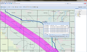
Click to Enlarge Challenge: After performing
a business process analysis for processes related to coal-bed methane permitting,
the State of Wyoming determined the existing inter-agency procedures could be made
more efficient by enhanced data sharing and collaboration. As part of Governor Freudenthal's
Streamlining and Strengthening (S&S) Initiative, the Natural Resources Gateway was
developed to serve as a one-stop portal for geospatial and permitting information
from multiple State and Federal agencies.
Solution: Pomona Consulting
designed and developed an innovative and user-friendly geospatial
portal for the integration, display, and analysis of spatial data from a number
of sources and agencies. The portal, developed using ESRI ArcGIS Server 9.3, leveraged
a diverse range of technologies, including ArcObjects, .NET, Web ADF, and SQL Server.
The application first integrated spatial data from a number of sources, aggregating
previously disparate data sources into one centralized, up-to-date repository. The
portal was then designed to allow non-GIS specialists to easily find and perform
advanced querying and spatial analysis in a user-friendly and intuitive manner.
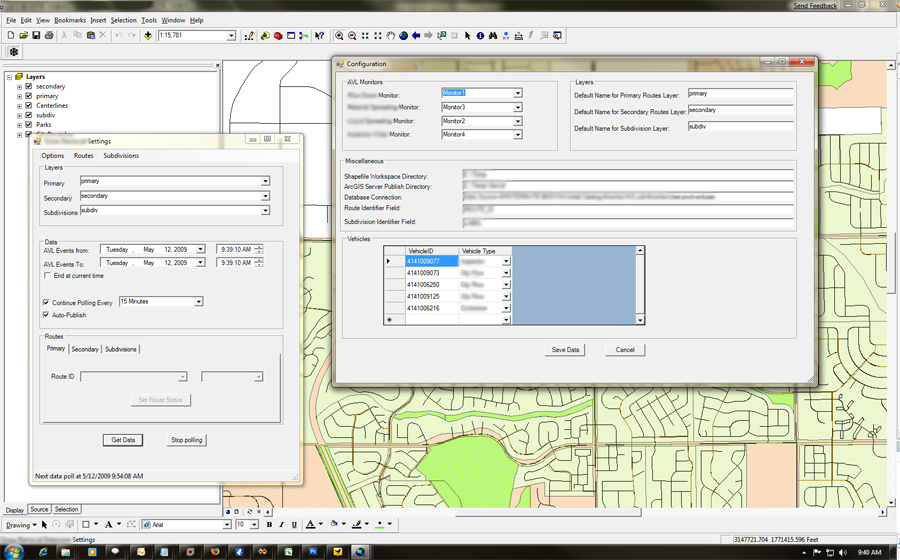
Automated Vehicle Location - ArcMap Extension
Colorado Municipality
Click to Enlarge
Challenge: The customer was in the process of integrating industry-leading
Automated Vehicle Location (AVL) technology for city vehicle tracking, but needed
to process the raw data and publish it into a data product that would be both useful
and readily available to city residents.
Solution: Pomona Consulting partnered
with the AVL technology provider to develop a customized ArcMap Extension for the
Municipality. This application was developed using ArcGIS Desktop 9.3 and made heavy
use of ArcObjects and the Microsoft .NET Framework. The extension allowed specialists
to automatically import and track status changes from the AVL system in close-to-real-time,
importing data from a central server. The application implemented several business
rules to automatically change status of spatial data as it was processed, and automatically
published to an ArcGIS Server instance to allow residents instantaneous access to
the information.
GIS Situational Assessment
State of Wyoming - State Agency
Click to Enlarge
Challenge: The customer, a Wyoming state agency, was undergoing
a multi-year re-engineering of all major internal IT systems. As part of this effort,
the customer was seeking assistance in understanding their current utilization of
GIS within individual departments, and recommendations on how geospatial technologies
might be beneficially implemented as part of phased system development.
Solution: Pomona Consulting undertook
a review of all existing spatial assets, internal technical capabilities, and existing
business processes which leveraged geospatial technlogies. We then conducted a number
of on-site interviews with key stakeholders from various divisions within the agency.
After review, we developed and presented a comprehensive GIS Situational Assessment
to stakeholders within State government, summarizing the current state of GIS adoption,
and making a series of recommendations for moving forward.
|